Using Lakes to Monitor the Health of the Planet
Using Sensors and Cross-Disciplinary Teams to Understand Complex Ecosystems Quickly
This case study of the PASEO project follows the story of a group of 24 biologists, engineers, and computer scientists as they teamed across two continents to model and monitor an unusually salty chain of lakes in Argentina. The PASEO team's rapid sampling and modeling approach may serve as a useful template for others who want to wrap their minds around what's going on with complex real-world systems really quickly.
NETTING IT OUT
How can you create a virtual, yet real-world model of your business? How can you monitor all the inputs and variables in a complex end-to-end process? Whether your business involves running airlines, keeping supermarket shelves stocked, providing cost-effective insurance, delivering electric power, or manufacturing and selling apparel, perhaps there’s a new way to think about monitoring and modeling your business and its ecosystem.
This case study highlights some current best practices in environmental engineering—practices that may also be useful to forward-thinking business strategists. The best practices are:
1. Use multiple, distributed sensors to capture real-time feeds about physical phenomena.
2. Build a virtual model based on these real-time data feeds to understand what’s going on and how things interrelate.
3. Use metadata frameworks that others are using to model similar phenomena so that you can compare and detect patterns.
4. Instrument quickly. Don’t spend years; spend days.
5. Build cross-disciplinary, cross-cultural teams to work on high-learning, high-performance, time-bounded projects.
We have yet to find anyone who is modeling their business in this way, but it seems logical that if scientists and engineers can sense, detect, model, and control real-world ecosystems, we should be able to do the same for our business ecosystems—most of which are made up of physical people doing physical processes.
MODEL LAKES AS EARLY WARNING SYSTEMS
How can you quickly and accurately monitor water quality anywhere on the planet? How easy is it, using today’s observational technologies—sensors, actuators, GPS, computer models, wireless Internet, and off-grid energy sources—to quickly characterize a complex ecosystem that is under stress? Can you compare and contrast the biological processes in lakes around the world? Those are some of the questions that Tom Harmon and his colleagues sought to answer as they headed to Argentina in April 2008.
Dr. Tom Harmon is Professor of Engineering at the University of California, Merced. He is an environmental engineer who has been active in promoting the use of embedded sensors for environmental research. He coordinated this research field trip by convening a group of 12 American professors and graduate students—environmental engineers, biologists, computer scientists, hydrologists, and electrical engineers—with an equivalent cross-disciplinary team of 14 Argentinean researchers. They set out to document the microbial biodiversity on a uniquely variable chain of five inland lakes in rural Argentina in less then five days.
This PASEO 1 project is a good example of how today’s scientists are using distributed, embedded sensors to model the environment. The approach used by the PASEO team could be used in any situation in which it’s important to quickly monitor and model water quality. For example, when a Tsunami, hurricane, or other natural disaster leaves an area devastated, or when there’s a problem with flooding, droughts, or polluted beaches.
The PASEO team’s rapid sampling and modeling approach may also serve as a useful template for others who want to wrap their minds around what’s going on with complex real-world systems really quickly.
The Mission: Characterize a String of Saline Lakes in Argentina
The Encadenadas del Oeste 2 lake system was once referred to as “the Pearls of the Pampas.” The northernmost lake in the chain is moderately salty; the southernmost lake in the chain is nearly as salty as the Dead Sea. This natural salinity gradient is caused by a combination of the climate, underlying sediments, and the lakes’ relative elevations. Recently, however, Argentinean scientists have become aware that the lakes have become increasingly polluted due to agricultural run-off, municipal waste water effluent, and urban processes upstream. Tom Harmon explained, “For us [the U.S. environmental scientists], it’s a little like going back in time, to what things were like before the Clean Water Act went into effect in the U.S. The concentrations of nutrients we see in these Argentinean lakes are 100 times higher than we would have.”
Dr. Gerardo Perillo, the Vice Director of the Instituto Argentino de Oceanografía (IADO) in Bahia Blanca, south of Buenos Aires, was “…excited about this project, because we had been trying to mobilize a group of hydrologists and environmentalists to look at this area. There are a lot of excellent scientists in Argentina. But they have a really hard time getting funding for instruments and gear. To the Argentinean scientists, the issues are obvious. But the rest of the world doesn’t really know about this.” Through a National Science Foundation grant that promotes cooperation between U.S. scientists and scientists in other countries, Harmon was able to provide a win/win experience—his students and colleagues could deploy state-of-the-art sensor technology to model a complex ecosystem, and the Argentinean scientists gained access to the equipment, the experience, and the data they needed to model and document the local environmental issues.
Sensors in Use for Environmental Studies
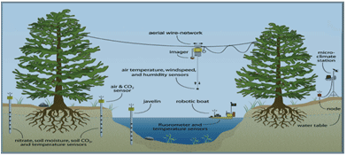
“Illustration of a multi-scale sensing system. Multi-scale sensing systems can share data among different platforms for efficient use of sensing resources. For example, low resolution images mounted on a robot moving between trees can communicate measurements to static or mobile sensors below to identify areas requiring higher resolution measurements. Illustration: J. Fisher, UC Merced.” Figure 2.5, page 17 published in 2007 in a CENS white paper entitled: Distributed Sensing Systems for Water Quality Assessment and Management .
Their goal was to study the relationship between water salinity and the biodiversity reflected in the bacteria and phytoplankton across the chain of lakes, and to use observational sensors to document the water quality and mixing conditions in the lakes. An equally important goal was to give students and researchers the opportunity to plan and execute a challenging international scientific collaboration in order to gain a more global perspective about their research...
Sign in to download the full article
0 comments
Be the first one to comment.